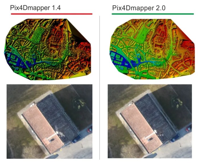
 Pix4Dmapper 2.0 is the latest version of the most simple and powerful aerial and terrestrial Photogrammetric software in the world. It is a programme which converts images and videos into extraordinary 3D models, point clouds and othomosaics. It distinguishes itself from other similar solutions for its simplicity to use as it is very user-friendly. Many have asked: “what’s new in latest Pix4Dmapper version? What issues have been solved? What are the new functionalities?” Let’s start from the new DSM generation algorithm and the ortomosaic. In this new version, the result quality has ben highly improved, especially in the reconstruction of rooftop edges, road sides and in general, of all those structures with prodrutent edges. A weakness many users had notified regarding the previous versions. How about an example? In the image below you can compare the DSM and the orthomosaic of the old and newPix4Dmapper versions.
  Fig. 1 – Pix4Dmapper 1.4 vs Pix4Dmapper 2.0 Another substantial change is the orthomosaic editor. With the new Pix4Dmapper you will be able to edit the mosaic surface in real time.visualizing and correcting the preview of the result without saving the whole orthomosaic.
  Fig. 2 – New Pix4Dmapper 2.0 Mosaic Editor del nuovo You will be probably wondering if you can generate the orthomosaic from any angle at this point? Of course you can! In the 2.0 version you will be able to generate the orthomosaic of building fronts, bridges, architectonic structures and much more. You will also have a new tool in RayCloud which will allow you to define an orthoplane and to generate the orthomosaic.
  Fig. 3 – Pix4Dmapper orthoplane Editor in rayCloud You have already used the previous Pix4Dmapper version (1.4) to process projects with no GPS coordinates? Surely you must have had problems when visualizing your 3D Model. Your 3D Model was upside down unscaled and you had no idea why? With the new version you wil no longer have this problem. Now you can rotate and orientate the processing result most accurately with absolutely no problem directly from rayCloud.
  Fig. 4 -Tools for 3D Model orientation and scale la scala del model Pix4Dmapper There is another new feature which will make you projects even more simple to achieve! Here it is! In this version of Pix4Dmapper you can dirctly import videos and carry out processings. You don’t have to worry about overlapping anymore. More new features:
- Tie point increase in projects with low overlapping such as agricultural fields
- Projects with georeferenced images processing speed increase
- New simplified option menu
- Default templates to simplify the processing options
- New options which will allow to set processing options
…. and much more. You can’t wait to download the latest Pix4Dmapper version? Click here and download it right now!
If you are a Land Surveyor you might be interested in Analist, Land Survey Software which integrates magnificiently with Pix4Dmapper. Do you want to present your 3D Models and create spectacular videos in real time? Find out about the new OneRay-RT.

